The have been at least 400 OpenStreetMap editing sessions in Haiti since the quake hit. Mostly tracing Yahoo imagery, and gleaning information from old CIA maps. We also just received permission to use GeoEye imagery acquired post-event … that will allow us to tag collapsed buildings. Many relief groups are deploying now, many checking in with the CrisisMappers list (the main locus of the wider humanitarian tech community), and they are making inquiries into OSM data and requests for particular features. Dozens of mappers and developers are lending a hand, coordinating on the OSM Haiti WikiProject and IRC and the OSM talk list … standing up services, including 5 minute extracts in Shapefile and Garmin formats, and maps with hill-shading. Just the start to relief and reconstruction effort we hope to contribute to.
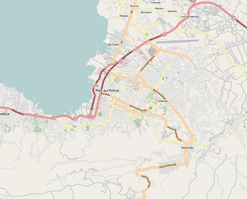
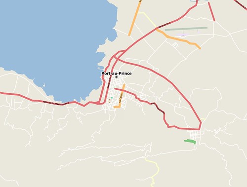
Two images to show how we’ve progressed … the first OSM Port au Prince just now, the second OSM before the earthquake.
I’ll be on twitter with updates … though I’m due to fly tonight to Ireland.
Pingback: Haiti Earthquake Mapping | The Fiducial Mark
Pingback: Crisis Mapping in Haiti : netzpolitik.org
Pingback: OSM Maps Port au Prince in Haiti Response | Avencia Atlas
Pingback: DC Haiti CrisisCamp volunteers work to digitize satellite images – CrisisCommons::Haiti
Pingback: Disaster Donations in An Age of Disruption | eJewish Philanthropy: The Jewish Philanthropy Blog
Pingback: OpenStreetMap update in Haiti | CroAxis.com
Pingback: « Haiti Digital Bibliography
Pingback: OpenStreetMap unterstützt Helfer in Haiti
Pingback: Kartographie der Krise | Open Data Network
Pingback: igorbrejc.net » Fresh Catch For January 18th
Pingback: Krisensichere Aufklaerung | stk
Pingback: topografoi.com » Ο σεισμός στην Αϊτή
Pingback: News Roundup – Geodesign, ArcGIS 9.4 Goes to 10, Haiti Disaster Response | Fuzzy Tolerance
Pingback: How the web has helped in Haiti « Nestoria Australia Blog